Route Details
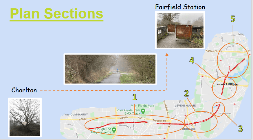
- From Chorlton to Fairfield station
- Distance: 5.4 miles.
- Type: Disused railway path, no hills and largely traffic free.
- Surface: Tarmac
- Path Number 6
Route Description
The Fallowfield Loopline is an attractive, largely traffic-free walking and cycling route which follows a former railway line. The route is a classic urban railway path, ideal for families and new cyclists who need to build up their confidence away from road traffic. It forms a green corridor running about one mile south of the city centre, linking parks and open spaces.
The Loopline connects Chorlton to Fairfield station and includes many reminders of its past as a railway line. The route begins at St Werburgh’s station in fashionable Chorlton. It runs through the thriving suburb of Levenshulme, through to Debdale Park, Gorton reservoirs and up to Fairfield station.
The Loop also connects to Route 60, which uses the in-filled canal to take you up to the Velodrome, the City Stadium and the Ashton Canal.
What we plan to do and why we want to do it
On many parts of the path, we simply seek to maintain what is there. In other sections we have identified opportunities to enhance habitats. We always aim to keep a safe and open feel to the path which sometimes requires us to undertake tree and scrub management as well as cutting grass directly adjacent to the path to prevent it from causing an obstruction. We also thin trees where it would improve the woodland health and we clear around some of the older trees to release them from the competition of younger more vigorous trees and allowing them to be fully appreciated by route users.
As you read on, you can see that the path has been split into 5 sections each with a specific focus beyond this general management. There is a brief description as to the nature and proposed management of each section.
Environmental Management Objectives
Restoring and enhancing the existing grasslands and woodlands along the route
Creating species rich habitats in suitable locations
Improving connections between habitat patches in the wider landscape
Providing suitable opportunities for nesting and hibernating wildlife
Increasing the abundance and diversity of foraging resources such as flowers, seeds, berries and insects along the route
Joining up habitats on the trail with Highfield Country Park Local Nature Reserve to encourage local wildlife to spread on to the route
Social Management Objectives
Providing volunteering opportunities for local people
Working with local businesses to manage the trail
Providing a setting which promotes and facilitates health and wellbeing
Creating a safe and welcoming environment for all
St Werbergh’s – Slade Lane
An section of path with many mature broadleaved trees, including sycamore, oak, willows and aspen. This section of path has
some issues with invasive plant species and fly-tipping
We would like to…
1/ Reduce the presence of invasive snowberry, rhododendron, spirea, and laurel and prevent any negative impacts it may have on the trail’s biodiversity or its neighbours.
2/ Clear fly-tipping and engage neighbours who deposit garden and household waste on the trail
3/ Assess and actively manage the poplar species which may grow too large for the trail.
Slade Lane to Nelstrop Road North
An open section of the path with food growing, grassland, scattered broadleaved trees and scrub
We would like to…
1/ Improve the species diversity within the grassland by implementing a traditional cutting regime and introducing new species through green hay application if required.
2/ Add to the food production in this section by planting more fruit trees.
3/ Create shallow ponds to increase the opportunities for wildlife
4/ Undertake habitat improvements on the open land adjacent to St Andrews CofE Primary School
Nelstrop Road North – Shillingford Road
A young woodland containing ash, aspen, willow and native shrubs.
We would like to…
1/ Clear the non-native invasive laurel
2/ Increase the food growing potential of the site by planting fruit trees and bushes
3/ Plant some new trees and create some shallow ponds to increase the habitat for wildlife.
Shillingford Road – Gore Brook
An open ash, cherry and willow woodland with areas of open grassland.
We would like to…
1/ Improve the species diversity within the grassland by implementing a traditional cutting regime and introducing new species through green hay application if required.
Gore Brook – Boothdale Drive
A maturing native woodland with small pockets of black poplar trees and some pond/wetland areas.
We would like to…
1/ Work with neighbours to see some coppicing of the black poplar to remove the risk of them obstructing the path in the future, and to create habitat diversity.
2/ Manage the ponds to maximise their benefits to wildlife
3/ Manage grassland and wetland between Alston Road and Green Fold

[…] Sainsbury’s 150th birthday partnership Sustrans 2020 Draft Habitat Management Plan […]