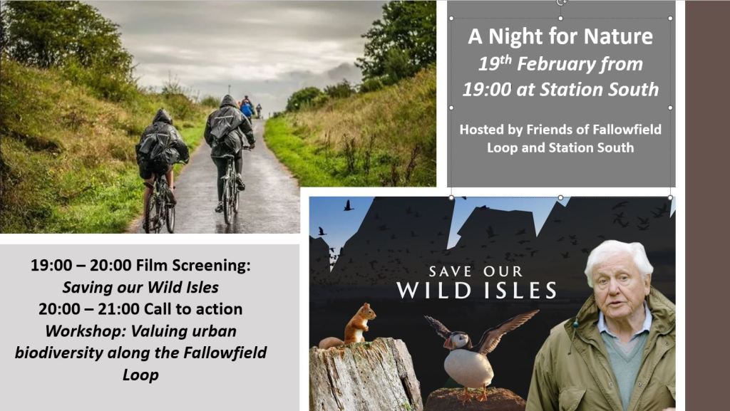
7pm on 19th February at Station South
Posted in Conservation on January 25, 2025|
Posted in Community orchards, Conservation, Improvements on May 14, 2023|
Next members’ meeting:
Monday 15th May, 7.30pm, Union Chapel, Wellington Road, Fallowfield.
Mayor’s Challenge Fund Development and Improvement Project.
We still have not received any official communication from Manchester Council, apart from the project being ‘downgraded’ .Information from the Manchester Walking and Cycling Forum on 14th March, which was attended by a couple of FotFL members, was:
‘Manchester Cycleway (the Fallowfield Loop) – The Safer Streets funded scheme has now commenced with some site clearance underway in the Yellow Brick Road area. Final designs are being prepared for other interventions that include improvements to access points, replacement/reinstatement of some fencing, removal of some barriers/blocks on path and resurfacing. It is expected that these works will be completed by Sept 2023.’
Tim Hollins, the Sustrans Network Development manager in the North West, says that two things that Sustrans are very keen for the Safer Streets Fund to achieve is to improve access barriers and for resurfacing along the two sections at Shillingford Road and from Withington Road to St Werburgh’s tram stop where there is tree root damage. They are currently discussing with MCC about what can be achieved using a mixture of Sustrans maintenance funds and the larger SSF pot. MCC would like the SSF pot to cover the Yellow Brick Road as well as the Floop so we will be asking Oliver Collins (SSF Project Manager) to mediate and make sure that there’s a fair spread of funding.
Safer Streets Funding – our possible input.
Frances McCann reports:
The Friends of the Fallowfield Loop have now linked up with the Safer Streets Funding development worker, Anna Smith. Anna has a 7 hour a week contract (until the end of 2023) to undertake community development work in relation to The Fallowfield Loop. She is making links with schools and community groups, doing promotion work and setting up Loop related activities.
The £453,000 Safer Streets funding is from the Home office. This allocation is managed through joint working of the Greater Manchester Combined Authority, Transport for Greater Manchester and Manchester City Council. In relation to the Fallowfield Loop, Anna is also looking to make contact with Sustrans.
Ian Barker has, on behalf of The Friends of the Fallowfield Loop, sent a list of issues and concerns, particularly in connection to repairs and safety matters that need attention, to the GMCA officer, Oliver Collins, who has oversight of the project development. He has also shared this with Anna Smith.
We hope that Anna will be able to give an update of the work she has been doing for the July Newsletter, it is also hoped that she will be able to come as a guest speaker to the July meeting, Monday 17th July.
David Beetham memorial tree planting.
On the 15th April 40 cyclists took a ride round the orchards and ended up at Station South for tea and cakes. David Beethams’ relatives then ceremonially planted an apple tree in his memory in a large container on the corner of the station site.
Orchards projects.
The orchards are looking good at the moment, with a good crop of blossom on most of the trees. Over the next couple of months, the orchard group will be looking to remove ground level weed growth round the trees and larger encroaching vegetation such as brambles and self seeded willow branches.
If you are interested in helping with orchard work please contact Dick Venes via email: rjvenes@waitrose.com.
Quadrants workday
One recent workday Ian Barker’s group re-seeded a bald unofficial path from the Loop to the Station South site. This was the original route of the path which Ian managed to get relocated to preserve the large ‘performance’ area of grass on the north west ‘Quadrant’. Unfortunately we have had no recent contact from the ‘Handlebards’ group who have put on Shakespeare plays on the site in previous years, so if anyone has any ideas about possible arts performances there this coming summer please contact us.
Eddie Johnson talk.
Eddie Johnson, Hon President of the Friends, will be giving an illustrated talk about the Fallowfield Loop railway line on 26th June at the Union Chapel. Please book the date in your diaries – we will be sending out more details in due course.
Nature Walks
The April circular walk from Athol Road and back, via Hough End Fields and Red Lion Brook was well attended and a number of harder to spot birds were heard and seen. These included: willow warbler, blackcap, stock dove, greenfinch and bullfinch.
NB Due to the unavailabilty of walk leaders in May and June, the next walk will not be until July, when we hope to have Fungalpunk Dave return for another exciting Floop Safari !
The future of the Friends
As previously stated, currently we are operating with a soon to retire Chair, no Hon Secretary and a stand-in Hon Treasurer. Past appeals for members to volunteer for Officer positions have failed to attract anyone so far, so we are currently facing disbanding the Friends organisation at the next AGM. If this happens, our Constitution states that ‘ in the event of the dissolution of the Association, once all liabilities have been met, any money or property left over shall be transferred to such charitable organisations as members deem suitable.’ If you are interested in helping the Friends group continue in the future the time to volunteer is now!
If no volunteers come forward, we will likely formally disband the Friends at the September meeting, which will be our AGM. The Hon Treasurer is currently sitting on about £3,000 in our bank account and would like to spend it on something useful on the Loop rather than bequeath it to a related charity. So, if you have any ideas for suitable expenditure, please contact Dick at rjvenes@waitrose.com, or by phone to discuss on 0161 224 3843.
Posted in Conservation on January 30, 2023|
Posted in Conservation on December 5, 2020| 1 Comment »
Route Details
Route Description
The Fallowfield Loopline is an attractive, largely traffic-free walking and cycling route which follows a former railway line. The route is a classic urban railway path, ideal for families and new cyclists who need to build up their confidence away from road traffic. It forms a green corridor running about one mile south of the city centre, linking parks and open spaces.
The Loopline connects Chorlton to Fairfield station and includes many reminders of its past as a railway line. The route begins at St Werburgh’s station in fashionable Chorlton. It runs through the thriving suburb of Levenshulme, through to Debdale Park, Gorton reservoirs and up to Fairfield station.
The Loop also connects to Route 60, which uses the in-filled canal to take you up to the Velodrome, the City Stadium and the Ashton Canal.
What we plan to do and why we want to do it
On many parts of the path, we simply seek to maintain what is there. In other sections we have identified opportunities to enhance habitats. We always aim to keep a safe and open feel to the path which sometimes requires us to undertake tree and scrub management as well as cutting grass directly adjacent to the path to prevent it from causing an obstruction. We also thin trees where it would improve the woodland health and we clear around some of the older trees to release them from the competition of younger more vigorous trees and allowing them to be fully appreciated by route users.
As you read on, you can see that the path has been split into 5 sections each with a specific focus beyond this general management. There is a brief description as to the nature and proposed management of each section.
Environmental Management Objectives
Restoring and enhancing the existing grasslands and woodlands along the route
Creating species rich habitats in suitable locations
Improving connections between habitat patches in the wider landscape
Providing suitable opportunities for nesting and hibernating wildlife
Increasing the abundance and diversity of foraging resources such as flowers, seeds, berries and insects along the route
Joining up habitats on the trail with Highfield Country Park Local Nature Reserve to encourage local wildlife to spread on to the route
Social Management Objectives
Providing volunteering opportunities for local people
Working with local businesses to manage the trail
Providing a setting which promotes and facilitates health and wellbeing
Creating a safe and welcoming environment for all
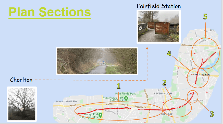
St Werbergh’s – Slade Lane
An section of path with many mature broadleaved trees, including sycamore, oak, willows and aspen. This section of path has
some issues with invasive plant species and fly-tipping
We would like to…
1/ Reduce the presence of invasive snowberry, rhododendron, spirea, and laurel and prevent any negative impacts it may have on the trail’s biodiversity or its neighbours.
2/ Clear fly-tipping and engage neighbours who deposit garden and household waste on the trail
3/ Assess and actively manage the poplar species which may grow too large for the trail.
Slade Lane to Nelstrop Road North
An open section of the path with food growing, grassland, scattered broadleaved trees and scrub
We would like to…
1/ Improve the species diversity within the grassland by implementing a traditional cutting regime and introducing new species through green hay application if required.
2/ Add to the food production in this section by planting more fruit trees.
3/ Create shallow ponds to increase the opportunities for wildlife
4/ Undertake habitat improvements on the open land adjacent to St Andrews CofE Primary School
Nelstrop Road North – Shillingford Road
A young woodland containing ash, aspen, willow and native shrubs.
We would like to…
1/ Clear the non-native invasive laurel
2/ Increase the food growing potential of the site by planting fruit trees and bushes
3/ Plant some new trees and create some shallow ponds to increase the habitat for wildlife.
Shillingford Road – Gore Brook
An open ash, cherry and willow woodland with areas of open grassland.
We would like to…
1/ Improve the species diversity within the grassland by implementing a traditional cutting regime and introducing new species through green hay application if required.
Gore Brook – Boothdale Drive
A maturing native woodland with small pockets of black poplar trees and some pond/wetland areas.
We would like to…
1/ Work with neighbours to see some coppicing of the black poplar to remove the risk of them obstructing the path in the future, and to create habitat diversity.
2/ Manage the ponds to maximise their benefits to wildlife
3/ Manage grassland and wetland between Alston Road and Green Fold
Posted in Conservation on June 8, 2019|
The Wildlife Trust for Lancashire, Manchester and North Merseyside has partnered up with Manchester City Council to celebrate and improve the wildlife and wild spaces on our doorsteps.
 Friends who value the Loop’s status as a wildlife corridor across Manchester might be interested in completing this survey and sharing their views of wildlife’s importance in general and of the Loop in particular. The survey is intended to help shape the way wildlife is protected and to contribute to the new 10-year vision for biodiversity in Manchester.
Posted in Conservation, Volunteering on August 21, 2016|
Members of the Friends were this weekend learning about scything on the Loop, with the sessions led by tutor Simon Tomlin who has written about the weekend here. Attendees learnt that cutting with a scythe is quiet, clean, and safe to use, and we hope that these skills will continue to be put to use in future management of the Loop!


Posted in Conservation, Fallowfield on February 8, 2015| 2 Comments »
Today the Friends were out, together with members of the Sale and Altrincham Conservation Volunteers, to plant a new hedgerow on the edge of the Loop, adjacent to the Sherwood Street entrance and on the corner with Wellington Road. The planted hedgerow contains a mix of native plants, predominantly hawthorn but also wild cherry, field maple, dog rose, hazel and blackthorn.


