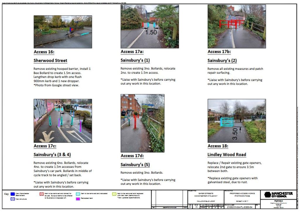
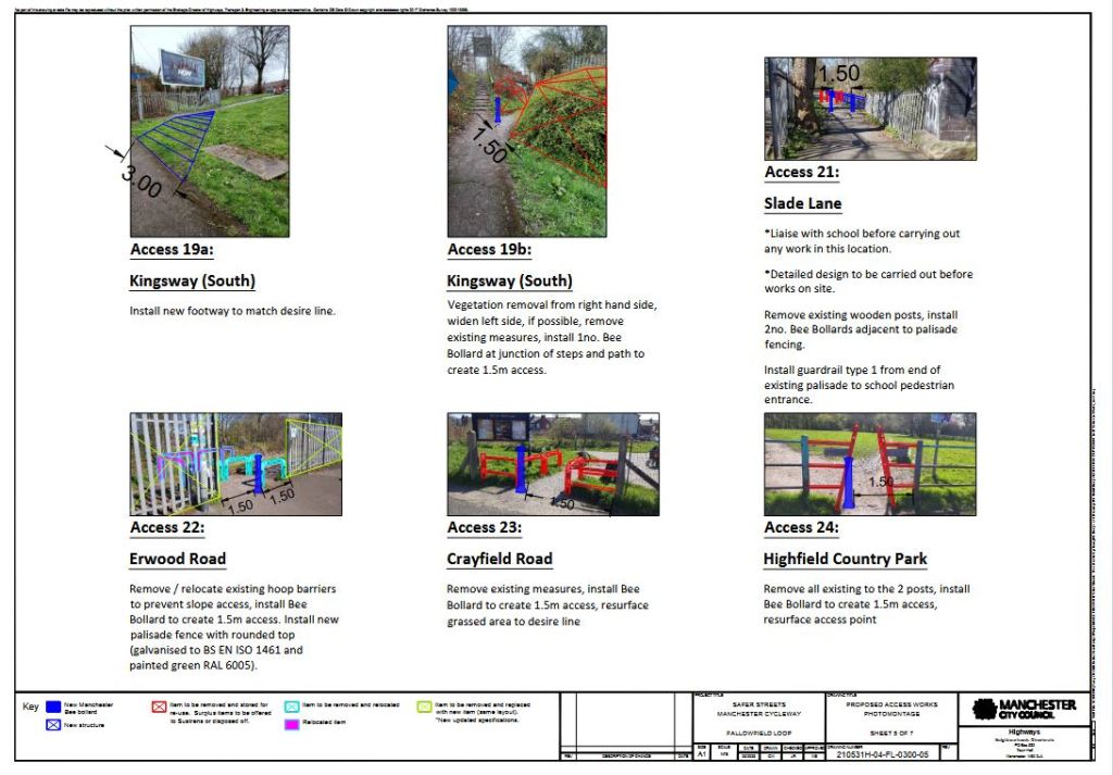
Feeds:
Posts
Comments

Archive for the ‘Accessibility’ Category

Seats

Introduction.

Fallowfield Loop friends, casual users of the Loop and TfGM personnel have noted that there are few places where walkers using the Loop are able to sit down and rest. Seating for such breaks in journey are important both for more able users of the route and to help those who would like to use the Loop to increase their fitness, but are deterred by the lack of resting places. Sustrans have indicated they would support proposals for an increased number of seats on the Loop and the Friends of the Fallowfield Loop (FotFL) have undertaken to examine possible locations for additional seats. At the last FotFL meeting, a distance between seats of 1km was suggested as a suitable starting point.

Existing seating.

Early in the life of the Loop, FotFL applied successfully for grant funding for two metal benches and Sustrans personnel installed them. These are located as follows:

  1. About 500m from St Werburgh’s Road Metrolink station on the north side of the path.
  2. About 600m from St Werburgh’s Road Metrolink station on the north side of the path.

Later an additional bench was installed, funding and installer unknown, location:

about 120m north west of the Alston Road access point, at the path junction to Abbey Hey Lane.

There is also relatively close off route seating:

  • at the Station South premises (old Levenshulme station)
  • by the reservoir, between the Debdale outdoor centre and the ‘Yellow Brick Road’ Loop access;
  • within the Godfrey Ermen playing fields, on the north side of the Loop in Abbey Hey.

Proposed seating.

Based on the 1km distance proposal, the following possible locations have been identified::

  1. At the point where Platt Brook emerges from a culvert, just west of Bethnall Drive allotments.
  2. At the Carrington Road entrance to the Loop.
  3. At the Kingsway entrance to the Loop.
  4. At Levenshulme ‘quadrants’ – Crayfield Road/Kersh Avenue entrance.
  5. At the Nelstrop Road access to the Loop.
  6. At the grassed area opposite Shillingford Road.

Costs.

The original green painted steel seats were supplied by Marshalls. On request they have provided FotFL with a quotation of £1415, including delivery, for one Ollerton Festival seat in a similar style. Presumably there will be a beneficial reduction in price for an order of 6 seats. There will be an additional cost for installation of the seats, which will involve digging two suitable holes, burying the seat legs in quick setting cement and making good. This was done by Sustrans for the original seats, but may be done by another contractor for the new seats.

Thus, for 6 seats, an estimated cost of £10,000 seems reasonable. FotFL are not in a position to fund such a project themselves, so would need to find a grant funder, possibly TfGM, as part of their Bee Active/GM Moving project.

Conclusion.

The above information is intended to provide a basis for further discussion by involved parties: FotFL, Sustrans and TfGM.

R.J.Venes, 7/6/25.

Read Full Post »

The city council have got money from the Safer Streets fund to look at making improvements to the Fallowfield Loop. There will be improvements to the access points and resurfacing some parts of the route where tree roots have made the path bumpy.

This is their statement:

The access point improvements will make the Fallowfield Loop more accessible for all users including wheelchair users, people with buggies and people who use adapted bikes. This will ensure there is a 1.5m gap at all access points on Fallowfield loop. In a previous consultation, it was noted by residents and ward members that quad bikes, trail bikes etc are a nuisance and demonstrate antisocial behaviour in some areas on a nightly basis, which is the reason that the current ‘A’ frames or access restrictions were originally installed at several entrance points to the route.

While they may help with this issue, they also exclude a lot of people including those:

  • on mobility scooters,
  • on bikes whose mobility is limited if they must dismount,
  • who can cycle but cannot dismount because of their disability and are effectively using their cycle as a wheelchair,
  • pushing prams etc

We are aware that making the route accessible for all will also allow anti social users to access the route, so as part of the Safer Streets project, additional work is underway including:

  • Development of new signage on the route that includes location identification. We are currently working through options to help with identification along the route – a suggestion has been to incorporate What.Three.Words so users are able to see where they are and this information can be used by GMP in reporting of crimes and Anti Social Behaviour. GMP will then be able to use the intelligence to allocate resources to specific areas rather than just Floop
  • Funded 2 bikes for GMP to use on the route. This should help officers get access to the route much quicker than by foot
  • GMP to use Floop for additional mounted patrols plus training for mounted team.
  • Additional mounted patrols will be bolstered by presence when horses are being trained to act as a deterrent for antisocial behaviour/Crime.
  • The GMP drone team can support the local teams through dedicated patrols plus again use the route for training to add additional deterrent.
  • Funding some additional GMP resource when works have been completed. Some funding is available to fund additional resource to target the Floop once the new access points have been installed.
  • Resurfacing is planned on two sections of the route: St Werberghs – Withington Road in Chorlton and parallel to Shillingford Road in Longsight.
  • Work is expected to start in September,

Read Full Post »

Members of the Friends have just produced a new and updated “Points of Interest” map!  The map has multiple layers which can be turned on or off by the user, showing the route of the Loop and points of interest on or accessible from it. Current map layers are:

  • Access points
  • Wildlife and natural features
  • Public resources and amenities
  • Landmarks
  • Historical interest
  • The railway 1891-1981

The Friends would like to continue to refine and update this over time so if you have suggestions for places to include on this map or notice any necessary corrections then please let us know!

Read Full Post »

Beelines!

Beelines logo

Beelines logo

The Friends have welcomed the Beelines cycling development proposals for Manchester, which have been developed with all 10 Greater Manchester local authorities and “will be the largest joined-up system of walking and cycling routes in the UK”.

Don’t forget that until the end of September there is an online process underway where you can view a map of the first draft of the proposals and zoom in on any areas that may be of interest, adding specific comments relating to development of the scheme.  See https://mappinggm.org.uk/ beelines/.

You will probably need to read the instructions to work out how to utilise the map layers and add comments.  We encourage all members of the Friends to engage with the consultation and share their views on how the proposals interact with the Loop in particular (and of course – we’d encourage everyone to get involved with the consultation for other routes and areas too)!

Read Full Post »

The final report for the “open-all-barriers” trial on the Loop has now been completed.  Please find a copy here (please note that it’s a 14Mb file!).

Read Full Post »

New Loop map and guide!

The Friends have recently undertaken a major revamp of our map and guide to the Loop. This is now complete, and has gone to the printers for an initial print-run of 10,000 copies.

The map A3 page contains much more detail on how to reach other cycle routes from the Loop (e.g., the Trans-Pennine Trail in both directions, the Ashton and Bridgewater canals, the route to Salford Quays and the different routes to the city centre), as well as showing more parks and green spaces. It also distinguishes which of the entrances are accessible for non-standard bikes.

The guide page is now divided into eight panels (instead of six) and can fit easily into the pocket.  The front and back panels explain what the Fallowfield Loop consists of; inside the first fold are panels headed THEN and NOW, with the former giving a brief history of the old railway line, and the latter showing its present transformation into a Greenway and wildlife corridor. The remaining panels deal with volunteering, cycling and walking contacts, use by the disabled and basic rules of the Loop (‘share with care’) respectively.

The PDF versions of the new map and guide are available on our Maps page.

Read Full Post »

Further to the positive response to the opening of barriers on the Loop, the Friends have been delighted that the Mayor of Manchester Carl Austin-Behan and his Consort Simon Austin-Behan have joined in, with a tandem ride to help celebrate the removal of the barriers and easier access to and along the path!  The Lord Mayor and his Consort also met local volunteers and members of the Friends to mark the occasion. Further details are on Sustrans’ website.

Read Full Post »

Another year, another Hallowe’en family-friendly bike ride extravaganza!

Hallowe'en Kidical Mass

Read Full Post »

Sustrans has published a news item describing how people with disabilities, parents cycling with children, tandem riders, and standard bicycle riders have overwhelmingly welcomed the trial opening of barriers on the Fallowfield Loop!  Read more on this here.

Read Full Post »

Feedback received on the trial of open barriers on the Loop and the results of the Friends’ surveys (online and face-to-face) have now been collated.  A fuller report will be completed and published in due course, but meanwhile this summary report is being shared with Sustrans for discussion.

Read Full Post »

Older Posts »